Wednesday, December 9, 2015

Saving the best for last! Dec. 7

The village of Chukhung (4730m/15,518') is a couple hours off the main trail that most tourists trek. We have managed to spend less time in the more heavily traveled areas. Lobuche, Everest Basecamp, Gorak Shep, and Kala Patthar are all heavily traveled areas which is fun when you get to meet new and interesting people but the downfall is when tea houses are full and loud, and you have to share the major vistas with others. Again this is not my typical backcountry backpack trip of solitude but rather an amazing cultural experience.....and I love it!
Top of Chukhung Ri with Lhotse towering over.

Today we climbed Chukhung Ri (5550m/18,208') (and remember "Ri" means "soft peak"....ha!). Our total elevation gain was 2690'. We had no idea that this peak and vista would be our favorite of this entire trek! We had the mountain to ourselves and found the perfect place to sit just out of the wind but in the sun to keep us warm. We sat on top of the peak for over two hours eating our grilled yak cheese sandwich lunch and absorbing the incredible view of so many huge peaks!!! These peaks may have not been Everest but these peaks were incredibly interesting and more majestic because of the glaciated flows "melting" down to the deep valleys. Wow! Two hours just flew by like an academy award-winning movie looking at the fourth, fifth, and sixth highest peaks in the world!
Panoramic view from the top!
John with views of Island Peak in front, Makalu (27,805') behind Island, a peak we are not sure about to the right by itself. 

The ridge up Chukhung Ri. 

Tomorrow we will move back down into the rat race again and head to Tengboche (3860m/12,660') and hopefully experience the serenity of the famous Buddhist temple. I do have to say that the business of other tourists is extremely low because of the after effects of the earthquake and the fact that this is late season for trekking. I cannot imagine what it would be like if it was mainstream trekking season! From here on out we will be decending over the next few days to Lukla where we began our trek. So it should get a little warmer and significantly easier on our bodies (except for my knees....darn knees!).

Tribute to my lil' Lhotse in front of Lhotse Peak (8414m/27,597'). 

What??? More oxygen??? Dec. 6

Using the power of the sun to boil their water. 

Another bluebird sky day but still a little chilly!  On our way to Dingboche (4410m/14,468') we passed a climber's memorial paying tribute to all the climbers who lost their lives on the mountain. 

Memorials on the ridge. 


We also acquired a few furry friends that I enjoyed more than John. Of course I am a sucker for fine furry friends with paws! I miss my Walter and Winston. 
We named him Cholatse. 

Stupa above Dingboche 
As we approached Dingboche we left the Khumbu valley and entered the Chhukung valley punctuated with many glaciers on all sides! Most of the hike to Dingboche was down hill and now we had to pay the piper and start climbing our 320 m/1049' to the village of Chhukung (4730m/15,518'). 

We will be sleeping much lower than we have been sleeping lately. Chhukung is surrounded by dramatic peaks including Lhotse, Ama  Dablam, and a fluted ridge off of Ombigaichan. 
Fluted ridge and the Chhukung glacier. 
Our sunset was heart warming despite the cold temperatures!

Giant Turdsicle and a Tinkle Ice Rink... (Dec. 5)


Our night at Gorak Shep was uneventful except for the NASTY bathrooms! I think the title of this entry speaks for itself describing both bathrooms! I refused to use them and strategically planned my tinkles by going when we were on our hikes and going after dark outside in the cold surrounded my mules in what I call the "sandbox."  Gorak Shep is located on the edge of a huge sand pit that would make an excellent sand volleyball pot!
Gorak Shep 

From Gorak Shep we headed farther up the Khumbu Glacier to the famous Everest Basecamp (5364m/17,598'). Because this time of the year isn't the climbing season there weren't any tents at the base (and I'm still trying to figure out where they would put the tents among all the rocks and ice) There was however a commemorative monument for this special place. For me I wanted to visit this place to pay tribute to the many souls that have been lost on the mountain and at Basecamp. I respect their sense of adventure and willingness to push themselves. It takes a lot of tenacity and commitment to just prepare yourself for Sagarmatha (Mt. Everest). 

Glacier/ice falls off of Nuptse

Got balance? At what point will this rock go?

It's crazy how the layer of rocks prevent the ice from melting!

We just couldn't get enough of Nuptse!

We enjoyed our return hike to Gorak Shep looking at the incredible ice flows coming off the mountains and down the valley. It's amazimg to see them up close!

After a quick lunch at our lodge (while my bladder was getting to the point of explosion) we decided to hike back down to Lobuche in hopes of finding a better place to spend the night. And that we did along with other fun travelers from the United States, Chile, China, and Great Britain! We enjoyed sharing stories by the fire and John and I enjoyed a "decent" bathroom!

Ok....just a little farther......and again? Dec. 4

We woke up to another bluebird sky in Dzongla after a much needed rest day. Our plan was to walk to Lobuche (4910m/16,108') and assess how John was feeling. 
Cholatse

This section of the trail takes us from one drainage to another drainage with new mountain views of Nuptse peak (7861m), Lhotse peak (8414m)(and name of my former sweet doggie), and of course, Mt Everest (8848m) the "roof of the world."  
I am pointing to Lhotse. I miss my pooch. Nuptse is to the left of Lhotse. 

We enjoyed our last views of Cholatse and Cho La pass and were welcomed by the Khumbu glacier valley! After a wonderful lunch of Sherpa Stew (noodles and veggies) we decided to push on to the village of Gorak Shep (5140m/16,863'). Walking up the Khumbu valley was like walking on the moon crossing glacial moraines and picking through Boulder fields.
Glacial moraine with Nuptse in the background. 
Khumbu glacier

 We arrived Gorak Shep around 3 PM and decided to try and climb Kala Patthar (550m/16,863') for the infamous sunset views of Lhotse, Nuptse, aaaaaand Everest! We were exhausted and this was definitely a push after the hike from Dzongla but this was our chance at the sunset experience! 
Gorak Shep with the trail going up Kala Patthar in the background. You cannot see the summit of Kala Patthar in the background. 
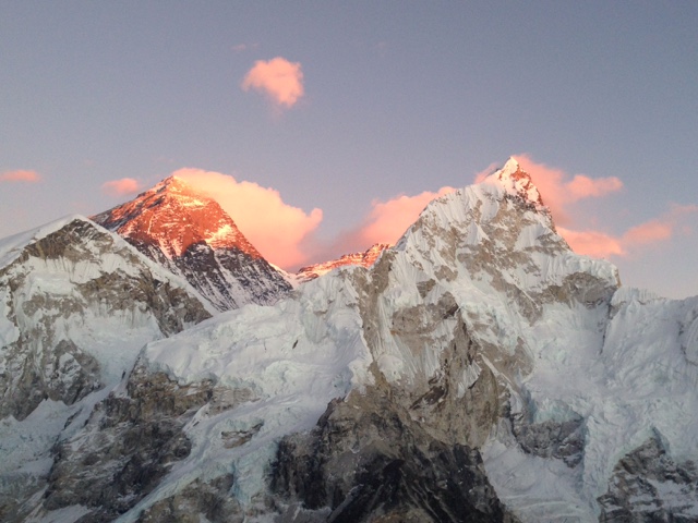
Everest on left and Nuptse on right. 
Top of Kala Patthar. 
I wish my phone could do this sunset some justice. :(

After the breath taking views and freezing our fanny's off we descended the 1,344 feet back down to Gorak Shep in the dark. The Stars were amazing!  Waiting at the lodge was our pre-ordered meal of potatoes, veggies, egg, and yak cheese AND some other familiar travelers we have been running into periodically throughout the trip. It was awesome to see familiar faces and share stories of the last few days with eachother!

Thursday, December 3, 2015

Just in the nick of time!!! Dec. 3

We must be lucky! One of the things locals told us about Cho La pass is that we shouldn't think about going over it after it snows. Well, guess what happened a few hours after we crossed????
Sunrise panoramic at the village of Dzongla. 

A yak admiring Ama Dablam. 

Lodge mates from Australia and Nepal. 

We woke up this morning to snow!!!!  We decided to take a rest day today since we have been going hard for many days and John has been fighting a cold and deep cough. Not good for high altitude. Plus our view from our lodge is incredible! Yay! Tomorrow we are off to Lobuche (4910 m/16,108') or  Gorak Shep (5140 m/16,863'). We will base our decision on John's health because going higher always exacerbates symptoms. :( 

You can't eat a steak in one bite.... (Dec. 2)

December 2nd:
Top of Cho La pass

We did it!!! Up until today we have been questioning our ability to get our bodies and backpacks over Cho La pass. Every guide we have talked to along the way to Gokyo raised their eyebrows when we said we were doing the trip without a guide and porter. Their reactions to our plan kind of freaked us both out but we also saw a few pairs of travelers pass us going the opposite direction who completed the pass without guides and porters. So we decided to take the risk and challenge and now we are sitting in a warm lodge in the village of Dzongla (4830 m/15,842') with an incredible view of Ama Dablam (6856 m/22,487'). 

We left this morning very early because this section of our trek is long and doesn't have any tea houses along the way for help or food. The temperature was well below freezing making it hard to stay warm even though we were climbing. We followed many snow cocks which are birds that remind me of Colorado's ptarmigan but larger. 
"Minor pass" behind us

We summited a "minor" pass which gave us a good look at the real deal pass we needed to haul our butts up! We actually were dumbfounded by what we were looking at because it looked impassible! So we looked at our map thinking we were looking at the wrong saddle but we soon realized that somehow we had to get up what looked like a vertical wall of rock. As we approached the wall we started to see contours of rockslabs and boulders. So we decided that instead of taking the entire pass on all at once, we were going to take it on by segments and just worry about getting from one cairn to the next before looking further on. We climbed on steep rock slabs, scree (really loose small rocks), and huge boulders. Balance and tenacity were essential! 
Yes, up that!

Every step was critical. Rock and ice. 

After about four hours of climbing we gained the pass. Wow! It was an entirely new view of mountains and the glacier we needed to cross. 
Hanging glacier above and glacier to cross below. 

The hard work was not done because we had to get on the glacier (which is steep) and then cross it without crampons. Then we had to start the painful journey down a similarly steep rock face we climbed on the way up. You may think I am crazy but I would rather climb a mountain twice than go down once. My 90 year old right knee screams at me with every step but luckily I am well equipped with Aleve and hiking poles!


The views of Cholatse and Ama Dablam were incredibly dramatic and made it hard to keep an eye on our footing. It's best to stop to gaze at the memorizing peaks!  

A few hours later we were sitting at our lodge sipping a hot cup of milk tea with panoramic views of a ton of new peaks including Cholhatse and Ama Dablam!  

Our one step at a time approach really paid off just like taking small bites of a steak! That kind of works for pretty much everything in life!
Thank you Tristan from Mrs. Miyauchi's kindergarten class for giving me the lucky Granby Bear bracelet! It's a lucky bracelet to have while traveling in the Himalayas!!! 

Up, up, and up.....we hope! Nov. 30 & Dec. 1

November 30, 2015
This is taken part way up Gokyo Ri. The village of Gokyo is next to the left side of the lake. 

Oh sweet Gokyo! This area is simply magnificent! Everywhere you look there is a prize for the eye! We woke up early to climb Gokyo Ri (ri means ridge or soft peak). The "soft peak" cracks me up because Gokyo Ri is  5360 m/17,585 feet high! It's a nontechnical climb which is probably why they call it a "soft peak". We started at an elevation of 4790 m/15,715 ft which gave us 570 m/1,970 ft. climb to the top. Surprisingly it was much easier than we thought it would be.  Just shows how amazing the human body is by its capacity to adapt to environmental changes. As we were climbing the clouds started to roll in and we hurried so we could get a view of Mt. Everest. Unfortunately we didn't get a view of the big girl at the top of Gokyo Ri but did sneak a peak on the way up. She is just amazing!!!
That is Everest just barely showing above the shadowed mountain in the center. 

Top O' Gokyo Ri

Tomorrow we have to cross the glacier dividing the lake and the mountains on the left. 

We contemplated moving on from the village of Gokyo towards Cho La pass but we decided to stay another night to let our bodies acclimatize some more in preparation of Cho La. We have both been anxious for Cho La because it is higher than we have been, it has a glacier crossing which can be a little sketchy, and we are carrying our own packs which makes the climb far more strenuous. Cho La pass has been the part of this trek that made us rethink hiring a porter but we are going to try it and neither of us are afraid to turn around. We understand the power of Mother Nature and aren't afraid to yield to her. Tomorrow (December 1) we will head to the village of Dragnag and then on December 2nd, if the weather cooperates, we will attempt Cho La!
Goodnight Gokyo!!!

December 1:
Everest is the tallest peak in the middle. 
I got up this morning with the full intention of reading my book and drinking coffee all morning......yeah right! I did get up and drink coffee and read my book but I just couldn't keep my eyes off the bluebird sky day and Gokyo Ri overlooking the village. So what do you think we did? Yep we climbed it for a second time and both john and I are glad we did it! At the top we got clear views of Everest. We also enjoyed panoramic views that we missed yesterday because of the clouds.  We met our fellow lodge mates at the top and celebrated with cookies for everyone! 
Everest

After the climb we packed up and headed to the village of Dragnag (also called Thangnak) just a short but complicated distance away. We had to cross a glacier/glacial moraine to get there. We both felt like we were walking on the moon because there wasn't any vegetation anywhere around us and there were hills of rocks and frozen lakes. It was crazy!
Glacier with Cho Oyu in background. 

Moonscape with Cholatse peak in the background. 

Food for thought.